


คำอธิบายของ 50 US States Map, Capitals & Flags - American Quiz
Do you know where is Vermont? What city is the capital of Wisconsin? In this app, you will find all 50 states of the United States of America! All 50 state capital cities! All state flags and outline maps! From New England and the Great Lakes to the California coast and the Alaska wilderness!
* Northeast (Massachusetts, Rhode Island, New Jersey etc.).
* Midwest (Ohio, Illinois, South Dakota etc.).
* South (Alabama, Texas, North Carolina etc.).
* West (Nevada, Oregon, Washington, and others).
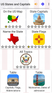
Questions are divided into six groups:
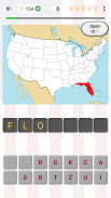
1) Guess the name or the postal abbreviation of the state highlighted on the US map (for example, LA is for Louisiana; OK is for Oklahoma).
2) Spell the names of the state capitals (e.g. Salt Lake City is the capital of Utah; Lincoln is the capital of Nebraska).
3) Recognize the state by its geographical borders.
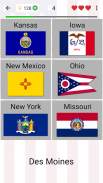
4) State flags.
5) Dates of admission to the Union: from the First State - Delaware (December 7, 1787) - to the 50th state Hawaii that joined on August 21, 1959.
6) State nicknames: famous like ‘Sunshine State’ for Florida or ‘The Grand Canyon State’ for Arizona; and less-known such as ‘Land of Enchantment’ for New Mexico or ‘Mountain State’ for West Virginia.
In each group, you can choose several game modes:
* Spelling quizzes (easy and hard).
* Multiple-choice questions (with 4 or 6 answer options). It’s important to remember that you have only 3 lives.
* Time game (give as many answers as you can in 1 minute) - you should give more than 25 correct answers to get a star.
Two learning tools:
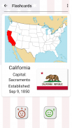
* Flashcards - browse information about each state without guessing.
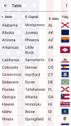
* Table of all U.S. states.
The app is translated into Spanish and 9 other languages - besides American English, of course.
It is a great educational game for everyone interested in the geography of the United States of America. Guess the capital and the flag of your state!
คุณรู้ไหมว่าเป็นเวอร์มอนต์? สิ่งที่เมืองเป็นเมืองหลวงของรัฐวิสคอนซินหรือไม่ ใน app นี้คุณจะได้พบทั้งหมด 50 รัฐของสหรัฐอเมริกา! ทั้งหมดเมืองหลวง 50 รัฐ! ทุกรัฐธงและร่างแผนที่! จากนิวอิงแลนด์และที่ Great Lakes ไปยังชายฝั่งแคลิฟอร์เนียและถิ่นทุรกันดารอลาสก้า!
* ภาคตะวันออกเฉียงเหนือ (แมสซาชูเซต, Rhode Island, นิวเจอร์ซีย์ ฯลฯ )
* มิดเวสต์ (โอไฮโอ, Illinois, เซาท์ดาโค ฯลฯ )
* ใต้ (Alabama, เท็กซัส, นอร์ทแคโรไลนา ฯลฯ )
* เวส (เนวาดาโอเรกอน, Washington, และอื่น ๆ )
คำถามจะถูกแบ่งออกเป็นหกกลุ่ม:
1) เดาชื่อหรืออักษรย่อไปรษณีย์ของรัฐที่ไฮไลต์ในแผนที่ของสหรัฐอเมริกา (ตัวอย่างเช่น LA เป็นรัฐลุยเซียนา; ตกลงสำหรับโอกลาโฮมา)
2) การสะกดชื่อของเมืองหลวงของรัฐ (เช่น Salt Lake City เป็นเมืองหลวงของยูทาห์; ลิงคอล์นเป็นเมืองหลวงของเนบราสก้า)
3) รับรู้ของรัฐโดยพรมแดนทางภูมิศาสตร์
4) ธงรัฐ
5) วันที่ของการรับสมัครไปยังสหภาพ: จากรัฐครั้งแรก - เดลาแวร์ (7 ธันวาคม 1787) - เพื่อ 50 รัฐฮาวายที่เข้าร่วมใน 21 สิงหาคม 1959
6) ชื่อเล่นรัฐ: ที่มีชื่อเสียงเช่น ‘ซันไชน์รัฐ’ ฟลอริด้าหรือ ‘แกรนด์แคนยอนรัฐ’ แอริโซนา; และน้อยกว่าที่รู้จักกันเช่น ‘ดินแดนแห่งเสน่ห์’ นิวเม็กซิโกหรือ 'Mountain State สำหรับเวสต์เวอร์จิเนีย
ในแต่ละกลุ่มคุณสามารถเลือกโหมดเกมหลาย:
* การสะกดแบบทดสอบ (ง่ายและยาก)
* คำถามแบบปรนัย (มีตัวเลือก 4 หรือ 6 คำตอบ) มันเป็นสิ่งสำคัญที่ต้องจำไว้ว่าคุณมีเพียง 3 ชีวิต
* เกมเวลา (ให้คำตอบมากที่สุดเท่าที่คุณสามารถใน 1 นาที) - คุณควรจะให้มากกว่า 25 คำตอบที่ถูกต้องที่จะได้รับดาว
สองเครื่องมือการเรียนรู้:
Flashcards * - เรียกดูข้อมูลเกี่ยวกับแต่ละรัฐโดยไม่ต้องคาดเดา
* ตารางของทุกรัฐในสหรัฐอเมริกา
ตรวจสอบที่ถูกแปลเป็นภาษาสเปนและภาษาอื่น ๆ 9 - นอกเหนือจากภาษาอังกฤษแบบอเมริกันของหลักสูตร
มันเป็นเกมการศึกษาที่ดีสำหรับทุกคนที่สนใจในทางภูมิศาสตร์ของประเทศสหรัฐอเมริกาของอเมริกา เดาเมืองหลวงและธงของรัฐของคุณ!
50 US States Map, Capitals & Flags - American Quiz--เวอร์ชั่น3.5.0
(19-01-2024)50 US States Map, Capitals & Flags - American Quiz - ข้อมูล APK
เวอร์ชั่น APK: 3.5.0แพ็คเกจ: com.asmolgam.statesแอปในประเภทเดียวกัน
คุณอาจจะชอบ...


